

|
|
|
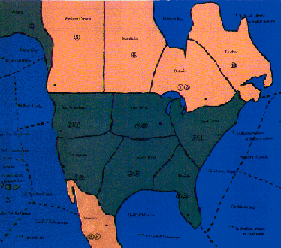
The War to End All Wars - North American Map Section
Sorry about the poor scan quality. Better pics are forthcoming in the near future. |
The North American map section connects
to all three map sections, all via sea zones. In the pacific, the four
sea zone areas connect with sea zone areas on the Pacific map from the
Coral sea in the south to Sea of Okhost in the north. In the Atlantic the
three sea zones connect with sea zones in Europe, while the southern most
sea zone also connects with a sea zone off the coast of West Africa. If
you are playing with the optional South American map that comes with the
Great War in Africa, the Mexico territory connects with the northern most
territory in S. America.
In most games these territories won't see any actual battles. Instead, they'll service as staging grounds from Canadian and American forces bound for Europe, or possibly the Pacific. However, in the Semi Historical Scenario, should Mexico enter the war, or should the United States end up joinning the Central Powers the war in America could rage every bit as violently as in Europe. With war against Canada and British, French, and Japanese navies crossing the oceans with invasion forces, the United States could face a great conflict on its own soil before it can realize full industrial mobolization. |
| Return to :
The War to End All Wars main page |
For questions, contact: stinger@guildofblades.com
Axis & Allies is a registered
trademark owned by Hasbro Inc. Its use here has not been
specifically authorized by Hasbro.
2003 copyright, Guild of Blades Publishing Group.